Turn location questions into defensible decisions
Analyze any region on Earth through a conversational geospatial workspace. Ask a question, bring your own context, and get evidence-backed results with citations, confidence, and visual layers.
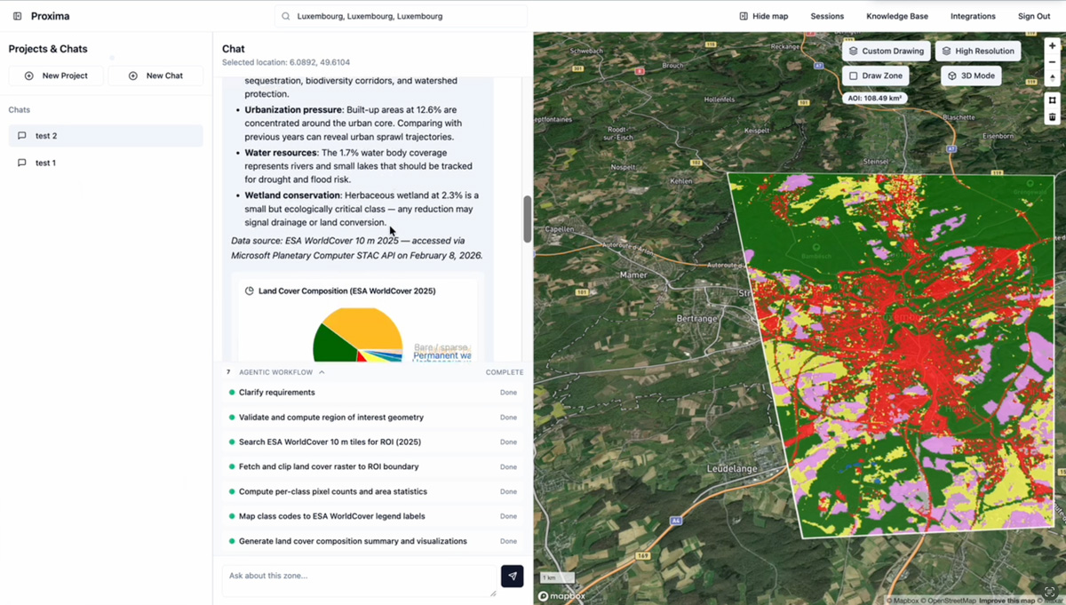
Draw a region, ask a natural-language question, and get a guided analysis without setting up a project.
Save investigations, bring in documents, and build a reusable operational view around one geography.
Turn analysis into watchlists, alerts, exports, and enterprise-ready handoffs.
From first question to operational clarity in three steps
Start with an area of interest, a portfolio, or a geography you need to understand. Proxima is built around location-first work.
Ask in natural language, upload supporting knowledge, and let the platform combine public geospatial context with your own operational inputs.
Results stream into maps, findings, and reports. When a workflow matters, promote it into a project and monitor the same region over time.
Built for teams that need signal, not just imagery
Proxima is not a static map viewer and it is not a generic chat wrapper. It is a location-first intelligence workflow designed to help teams investigate, compare, monitor, and communicate what is changing on the ground.
See applied workflowsNatural-language analysis
Ask the same kinds of questions decision-makers ask in meetings, not just the commands analysts know how to write.
Visual result layers
Keep spatial evidence visible with map layers, findings cards, charts, and side-by-side result views that teams can discuss together.
Project memory and context
Keep recurring work anchored to one geography, one client, or one operational problem instead of starting from scratch every time.
Exports, alerts, and API paths
Move analysis into client deliverables, internal reporting, monitoring, and enterprise integrations when the workflow matures.
Questions that become more powerful when the map, time, and evidence stay connected
The categories below mix what is already clear from the product direction with the way strong geospatial intelligence platforms grow in the market. Each one shows the kinds of questions Proxima is built to answer beautifully.
Monitor crop stress, water pressure, and field performance before problems compound.
For growers, lenders, and ag operators, Proxima can become the place where seasonal comparison, field-level anomalies, and portfolio-wide monitoring live in one workflow.
best for
crop health and irrigation watch
outcome
faster prioritization of field visits
mode
season-over-season tracking
example questions
- Which fields show the sharpest vegetation decline in the last 30 days?
- Where are irrigation patterns diverging from last season?
- Which farms need immediate follow-up after flood or drought exposure?
analysis types
Understand geographic exposure and post-event change across portfolios, not just single assets.
Proxima can support portfolio-level screening, catastrophe response triage, and recurring exposure monitoring for teams that need location-driven intelligence at underwriting and renewal time.
best for
risk concentration analysis
outcome
faster post-event screening
mode
portfolio watchlists
example questions
- Which insured areas have the highest flood exposure this quarter?
- Where did built-up footprint change after the latest event window?
- Which regions should move to closer monitoring before renewal season?
analysis types
Track ecological change with evidence that can survive scrutiny.
Environmental teams, conservation groups, and consultancies can use Proxima to stay close to land-cover change, habitat pressure, watershed signals, and recurring compliance checks.
best for
deforestation and habitat watch
outcome
stronger reporting and compliance
mode
baseline and trigger monitoring
example questions
- Where did forest cover change in the last six months?
- Which monitored areas show new pressure around protected boundaries?
- How has surface water extent shifted between the wet and dry seasons?
analysis types
Bring land-use, infrastructure, and planning questions into one shared operational view.
Public-sector teams can use Proxima to compare how regions evolve over time, understand corridor and infrastructure pressure, and communicate findings more clearly across departments.
best for
urban expansion and corridor review
outcome
clearer planning conversations
mode
shareable project workspaces
example questions
- Where has urban development expanded fastest in the last five years?
- Which infrastructure corridors show new encroachment or construction risk?
- How is land use changing around planned growth zones?
analysis types
Persistent area awareness becomes easier when change, evidence, and context stay linked.
Looking ahead, Proxima can be presented as a strong fit for security and defense teams that need repeatable regional awareness, infrastructure watch, and faster first-pass analysis around areas of interest.
best for
site activity and route observation
outcome
faster first-pass situational review
mode
regional watchlists
example questions
- What has changed around this installation since the previous observation cycle?
- Which access corridors show new activity or disruption signals?
- Where should analysts focus next based on recent regional change?
analysis types
Watch corridors, sites, and surrounding terrain with one workflow for planning and operations.
Energy, utilities, and infrastructure operators can use Proxima to review route pressure, vegetation or water signals, and site selection context without splitting the narrative from the geography.
best for
corridor and site watch
outcome
better pre-build and operating visibility
mode
network-level monitoring
example questions
- Which planned sites show the best surrounding terrain and land-use profile?
- Where is corridor encroachment increasing around critical infrastructure?
- Which monitored regions show water or environmental stress that could affect operations?
analysis types
The platform story extends beyond one dashboard screenshot
Proxima is strongest when it is described as a workflow that can compare change, explain trends, preserve evidence, and stay live over time. That is the story serious teams buy into.
Open the research pageChange detection
See what shifted between two points in time and why it matters.
Time-series tracking
Understand trend direction over seasons, events, or planning cycles.
Zonal comparisons
Compare regions, assets, or management zones without leaving the map workflow.
Monitoring
Turn one insight into an ongoing watch condition for the same area of interest.
Knowledge-grounded reporting
Bring in documents and organizational context so outputs align with the way your team already works.
Exports and sharing
Package analysis into key findings, reports, and enterprise-ready downstream workflows.
Structured for evaluation, growth, and enterprise deployment
The current product direction supports a simple credit model, with more room to tailor contracts as workflows mature.
Pro
$49/mo
500 credits per month
5 seats
For recurring analysis and growing internal workflows
Team
$149/mo
2,000 credits per month
20 seats
For shared workspaces, deeper monitoring, and multi-user operations
Enterprise
Custom
Custom credits and unlimited seats
Commercial terms shaped around the operating model
Best for API, governance, and long-running programs
Questions buyers and operators will ask
If the question starts with where, Proxima should be part of the answer.
Start with a single region, or talk to us about a broader enterprise workflow built around recurring geospatial intelligence.